Welcome
River Analyst is a web app featuring a novel database approach for leveraging hydro-environmental analyses of exponentially-growing, dataype diverse river data. To-date investigations of our field team resulted in an unprecedented open-source river database that can be queried and visualized for free (Query and Analysis tabs).
Access to the data upload feature (Upload tab) is restricted to authorized users only. User credentials can be obtained through our team to enable research collaboration. To request access, please contact us via the email addresses listed on the footer of this page.
Subsurface/ Surface Sediment Samples
246/ 77
IDO/ kf Depth Profiles
197/ 195
Points of Hydraulic Measurements
221
Description of measuring methods
Surface and subsurface sediment sampling
Sediment sampling involve collecting sediments with the help of shovels, for instance, and bringing them to the lab for drying (conventionally at 105 °C for 24 h) and subsequent dry sieving with sieves according to the Wentworth (1922) scale. Sieving analyses of surface and subsurface samples from the overlayer and underlayer, respectively, enable to derive several sedimentological parameters that characterize the substrate. Another method for subsurface sampling is the freeze core method (Carling & Reader, 1981), which involves pulling out frozen sediment samples from the riverbed with a tripod.
MultiPAC for substrate assessment
MultiPAC (Negreiros et al., 2023; Seitz, 2020) is a multi-parameter approach to assess riverbed clogging and vertical hyporheic connectivity, which consists of measuring multiple riverbed physico-chemical parameters, namely riverbed:
- grain size characteristics
- porosity
- interstitial dissolved oxygen (IDO)
- hydraulic conductivity (kf)
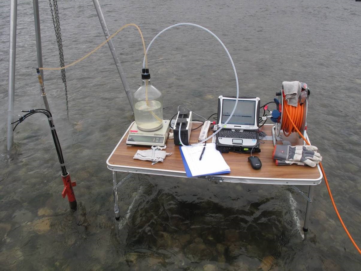
Measuring setup for the hydraulic conductivity (kf)
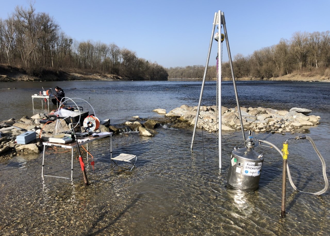
Measuring setup for the hydraulic conductivity (left) freeze core method (right)
In-situ flow velocity measurements
Acoustic Doppler Velocimeter (ADV) devices (e.g., Flowtracker2, SonTek) enables to determine multi-dimensional flow velocity vectors (x, y, and z) of surface flow. This data is crucial for the validation of hydrodynamic numerical models. Additional hydrodynamic data, such as turbulent kinetic energy (TKE), can be derived from measured temporal velocity fluctuations to investigate morphological features for habitat enhancement.
The FlowTracker2 uses acoustic Doppler technology to measure velocity at multiple points in a water column. The device consists of a handheld unit that houses the electronics and transducers, and a set of probes that are inserted into the water to take velocity measurements. The device can measure velocity in both shallow and deep water, and is suitable for a range of applications, in particular river or stream gauging.
Selected publications
Disclaimer
No warranty is expressed or implied regarding the usefulness or completeness of the information and documentation provided. References to commercial products do not imply endorsement by the Author. The concepts, materials, and methods used in the algorithms and described in the documentation are for informational purposes only. The Author has made substantial effort to ensure the accuracy of the algorithms and the documentation, but the Author shall not be held liable, nor his employer or funding sponsors, for calculations and/or decisions made on the basis of application of the scripts and documentation. The information is provided “as is” and anyone who chooses to use the information is responsible for her or his own choices as to what to do with the data. The individual is responsible for the results that follow from their decisions.
This web site contains external links to other, external web sites and information provided by third parties. There may be technical inaccuracies, typographical or other errors, programming bugs or computer viruses contained within the web site or its contents. Users may use the information and links at their own risk. The Author of this web site excludes all warranties whether express, implied, statutory or otherwise, relating in any way to this web site or use of this web site; and liability (including for negligence) to users in respect of any loss or damage (including special, indirect or consequential loss or damage such as loss of revenue, unavailability of systems or loss of data) arising from or in connection with any use of the information on or access through this web site for any reason whatsoever (including negligence).